Measuring snow depth
Published on 05.05.2007 - General Info
Measuring Snow Depth
© International Polar Foundation
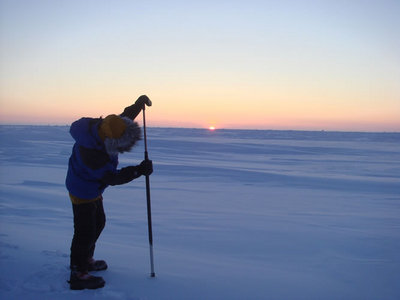
Yesterday, Hubert and Dansercoer took their fourteenth reading of the depth of the snow covering the pack-ice, part of a task assigned to them by the ESA for its forthcoming CryoSat-2 mission.
Thus far, we have not spoken much about it, but the Arctic Arc expedition has been asked by the ESA (European Space Agency) to carry out an important mission throughout its journey across the pack-ice. The task involves measuring the depth of the mantle of snow covering the ice at regular intervals (every four days).
This assignment is part of the CryoSat-2 satellite programme. This European satellite is scheduled to be launched in 2009 and will provide extremely precise information concerning changes in ice thickness, on both the sea and land for the entire region around the North and South Poles. These measurements are designed to raise key questions about the impact of climate change on the polar environment. When put in perspective, this mission is actually a technical feat of strength.
When you take into account the fact that the satellite will be travelling over 25,000 km/h at an altitude of 717 km above the Earth's surface and that it will be capable of measuring changes to the thickness of the ice down to a few centimetres using a complex instrument called a SIRAL altimetry radar device, it is nothing short of amazing. Given the objectives required and the importance of having accurate measurements to be able to assess changes in the environment, it is hardly surprising that the European Space Agency is doing everything it can to ensure that the data collected by CryoSat-2 is as precise and accurate as possible.
So, as a result, Alain and Dixie are spending a little of their time every four days taking accurate readings of the depth of the snow covering the Arctic pack-ice. These measurements will then be used by European researchers to determine the extent to which snow conditions can be forecasted in advance based on current climate models. They will also be used as reference points for methods designed to improve the accuracy of the maps CryoSat-2 will produce on the thickness of the sea-ice.


