Don’t get lost
Published on 12.06.2007 - The Arctic Arc
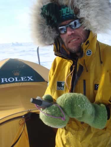
Alain Hubert and GPS
© International Polar Foundation
At the end of this extraordinary and historical odyssey, here are some useful pieces of information and tips on how explorers find their way about in polar regions.
The Global Positioning System (GPS) has revolutionised the modern polar adventurer's problem of knowing his precise position. GPS devices use a network of satellites that orbite the poles to provide virtually instant locations with an accuracy of about 50 metres.
Before GPS existed, explorers used a sextant and chronometer to calculate their position. They also needed to use an artificial horizon (which in the early days consisted of a plate filled with mercury) because the pack-ice in the Arctic Ocean is never flat â anyone who still doesn't know that is truly incorrigible. Measuring the height of the sun at midday (the meridian) enabled them to make a quick calculation on which latitude they were at. Calculating longitude was much more difficult, requiring the use of highly accurate chronometers and tables of ephemerides.
Once explorers had determined their position, they then had to set the direction they wanted to go in. When the weather was good, things were fairly straightforward. They could navigate by the sun and follow its shadow. In his book "Two Poles, One Dream" (Arthaud, Paris 2004), Alain Hubert gives a good description on how this system works: "Finding your position is based on a very simple principle: the Earth revolves on its axis once every 24 hours. So the sun passes through 360° in 24 hours, or 15° every hour. If you set your watch to solar time, the sun (in the northern hemisphere) will be exactly in the east (90°) at 6 in the morning, in the south (180°) at midday, in the west (270°) at 6 in the evening and in the north (360° or 0°) at midday. Let's suppose we want to head towards the North Pole and it is 9 in the morning. The sun will be at 135° (9 x 15°). The walker's shadow will then be at 135° + 180° (= 315°), in other words 45° to the left of the direction of the Pole (360°). All the walker has to do then is calculate this angle and keep to it for one hour. At 10 o'clock, his shadow will be at 30° to his left, 15° to the left at 11 o'clock, while at midday he will be walking on his shadow. At 1 o'clock, his shadow will be 15° to the right, and so on..."
For this expedition, Alain Hubert was given an Oyster Perpetual Explorer II by his main partner Rolex, which is specially designed to stand up to low temperatures and is fitted with a hand that does one revolution of the face in 24 hours, rather than 12 hours, like a conventional watch. This type of watch makes the walker's task easier, because once it has been set to solar time, all you have to do is point the hour hand in the direction of the sun to have north indicated by the direction at 0 hours.
That's how you navigate by the sun. But, as we have seen, the sun is not always visible and in fact it has hardly shone for more than a week out of the hundred or more days of the Arctic Arc expedition. So, what do you do then? You use the wind. Hubert writes: "Before the sun disappears, we record the direction of the wind indicated by pennons (small pieces of lightweight fabric) attached to our ski sticks. We then make ourselves walk, keeping the pennons in the same direction as the angle at which we are walking. It's not quite as accurate as using the sun, but the technique is still very effective. The only problem is, if the wind changes direction, we go with it. But taking a GPS fix every two hours enables us to get back on track..."
And if there's no sun and no wind?
Of course, it may happen that there is no sun and no wind. When that happens, you have to use a compass. But in the Arctic, being so near to the Magnetic North Pole (located at 82.7°Nâ114.4°O in 2005) makes the needle reading unreliable. The horizontal component of the magnetic field (which is what the compass reads) becomes very weak in relation to the vertical component and the compass tends to spin. You also have to remember to bring a map with you showing details of the magnetic declination.
Finally, anyone trekking through the Arctic has to take one final piece of data into account in order to find their way in these remote areas: the drifting motion of the pack-ice. We experienced this throughout the expedition and it was a major factor in the way the whole trek evolved, pushing the men towards the pole during the first half of their adventure.
You have to realise that there are two major movements that are two major features of the Arctic pack-ice: a spiralling anticyclonic current centred on the north of the Beaufort Sea and the great transpolar current that goes from the Bering Straits to the east coast of Greenland via the North Pole. The first of these movements takes five years to complete, but it can keep the ice rotating for much longer with only very little ice escaping each time around. The second movement takes three years to carry the ice formed along the coast of Siberia out into the Atlantic Ocean. The average speed at which the pack-ice moves close to the pole is 2 to 3 kilometres a day. However, when there is a depression in the area, this speed can reach 1.5 to 2% of the speed of the wind, with the movement following the direction of the wind, deflected 30° to 40° to the right by the Coriolis force.
The Website of the Day
A long article from the Washington Post ("Melting Arctic Makes Way for Man"), written by Doug Struck and dated 5th November 2006. The author was fortunate enough to travel aboard the Canadian ice-breaker "Amundsen" (see photo) and sail along the famous Northwest Passage. By interviewing various people (there were numerous personalities on board), he analyzes the effects (usually negative, rarely beneficial) that opening these extremely fragile waters up to commercial navigation in the future might have.


